| Trail #50 Detailed Trail Map |
| Statistics |
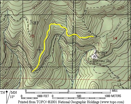
Length
1 mile
Elevation gain/loss (east to west)
Approximately +123', -154'
1 mile
Elevation gain/loss (east to west)
Approximately +123', -154'
| Survey Information |
Trail #50
To gain access to the east end of trail #50 start from Littlerock go west on 128th street, north on Waddell Creek road, west on the Sherman Valley road,
west on the C-Line to where Green Line #6 crosses the C-Line. Go north and west on Green Line #6 for about 1¼ mile. Trail #50 begins in the SW ¼,
SE ¼, NW ¼, Sec. 14, T17N, R4W. From here this trail goes in a westerly and then to the south and is 1.0 mile long. It does not cross any. There are 3
stream crossings. There are no bridges. This trail ends at the junction that is Mima Porter #8 and trail #50 and the C Line,in the NW ¼, SW ¼, SE ¼,
Sec. 28, T17N, R4W.

| Map 7.5 Minute Topographical (elevation lines are in 20' intervals) |
Click on the camera icons on the map for a helmet cam view of the section of trail the icon is on. Arrows indicate direction of travel for video.
Some video files are large, so be patient, they may take a minute or two to download. It will be worth the wait. A high speed internet connection is best for viewing.
Some video files are large, so be patient, they may take a minute or two to download. It will be worth the wait. A high speed internet connection is best for viewing.
| Elevation Profile |